Use Satellite Imagery to Anticipate Crop Needs
Every seed you plant this year represents an investment that you want to protect. But you can’t monitor issues on every acre all season with the naked eye. Add satellite imagery to your crop management toolbox to help you find specific zones in the field that might need your attention throughout the growing season.
Elevate your view
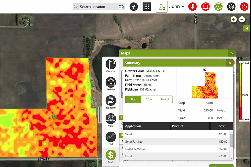
Whether it’s disease, insect or weed pressure, or nutrient deficiencies, in-season imagery paired with boots-on-the-ground scouting can help you pinpoint trouble spots so you can make timely management decisions. The WinField United R7® Tool delivers high-resolution satellite images, enabling you to receive detailed depictions of low- and high-vegetation portions of the field. On the ground, the tool’s GPS capability tells you exactly where you are in that field while scouting and your proximity to problem areas.
Keep in mind that just because a satellite image indicates a portion of a field has high biomass, that doesn’t necessarily mean it’s a trouble-free spot. A high biomass reading could signal weed pressure. That’s why it pays to have vantage points both in the air and at ground level to be able to tell the difference and take action if necessary.
One other thing to remember: In the later part of the season, satellite images taken just prior to the reproductive growth stage have been shown to correlate strongly to yield maps in grass crops. This can help make planning for harvest, and for the following season, more predictable.
Managing multiple fields
The R7 Field Monitoring Tool provides a daily low-resolution satellite image of your fields, which helps you benchmark them and track the rate of biomass accumulation. For example, if you have a field that is accumulating biomass at a slower-than-average rate, that field might have a nutrient deficiency or contain some drowned-out portions that need replanting. Or, as mentioned earlier, if biomass is accumulating more quickly than average, the Field Monitoring Tool can detect weed escapes. Instead of looking at individual fields every day, the Field Monitoring Tool allows you to get an overall view and know which fields you should be focusing on now and in the near term.
The Field Monitoring Tool also indicates where you should be increasing or cutting back on inputs. For example, if the tool shows that a particular field is trending up and contains a hybrid with a high response-to-fungicide score, you probably should be investing in a fungicide application. Conversely, a field that’s not performing very well could be an area where you may not need as many inputs to optimize ROI potential.
Managing multiple inputs
If you want to hone in on the performance of an individual field, the R7 Field Forecasting Tool can give you its moisture, nitrogen and potassium levels, helping you manage it to achieve optimal ROI potential. If the Field Monitoring Tool indicates the field is doing well, you can add in the Field Forecasting Tool to really drill down and see how much nitrogen or potassium you should apply to reach your high-end yield goals and when you need to apply them.
Talk with your local trusted advisor about how using tech tools from WinField United can help you dig deeper into your fields’ potential and more accurately allocate your inputs budget.
© 2019 WinField United. R7® and WinField® are trademarks of WinField United.
Elevate your view
Whether it’s disease, insect or weed pressure, or nutrient deficiencies, in-season imagery paired with boots-on-the-ground scouting can help you pinpoint trouble spots so you can make timely management decisions. The WinField United R7® Tool delivers high-resolution satellite images, enabling you to receive detailed depictions of low- and high-vegetation portions of the field. On the ground, the tool’s GPS capability tells you exactly where you are in that field while scouting and your proximity to problem areas.
Keep in mind that just because a satellite image indicates a portion of a field has high biomass, that doesn’t necessarily mean it’s a trouble-free spot. A high biomass reading could signal weed pressure. That’s why it pays to have vantage points both in the air and at ground level to be able to tell the difference and take action if necessary.
One other thing to remember: In the later part of the season, satellite images taken just prior to the reproductive growth stage have been shown to correlate strongly to yield maps in grass crops. This can help make planning for harvest, and for the following season, more predictable.
Managing multiple fields
The R7 Field Monitoring Tool provides a daily low-resolution satellite image of your fields, which helps you benchmark them and track the rate of biomass accumulation. For example, if you have a field that is accumulating biomass at a slower-than-average rate, that field might have a nutrient deficiency or contain some drowned-out portions that need replanting. Or, as mentioned earlier, if biomass is accumulating more quickly than average, the Field Monitoring Tool can detect weed escapes. Instead of looking at individual fields every day, the Field Monitoring Tool allows you to get an overall view and know which fields you should be focusing on now and in the near term.
The Field Monitoring Tool also indicates where you should be increasing or cutting back on inputs. For example, if the tool shows that a particular field is trending up and contains a hybrid with a high response-to-fungicide score, you probably should be investing in a fungicide application. Conversely, a field that’s not performing very well could be an area where you may not need as many inputs to optimize ROI potential.
Managing multiple inputs
If you want to hone in on the performance of an individual field, the R7 Field Forecasting Tool can give you its moisture, nitrogen and potassium levels, helping you manage it to achieve optimal ROI potential. If the Field Monitoring Tool indicates the field is doing well, you can add in the Field Forecasting Tool to really drill down and see how much nitrogen or potassium you should apply to reach your high-end yield goals and when you need to apply them.
Talk with your local trusted advisor about how using tech tools from WinField United can help you dig deeper into your fields’ potential and more accurately allocate your inputs budget.
© 2019 WinField United. R7® and WinField® are trademarks of WinField United.

Related Articles