Trusted Partner Aker Offers New Scouting App
As farmers and retailers, we know it’s important to have the latest news and insights about tools that can make using on-farm technology easier. To help you sort through the complex market, WinField United partners with highly regarded precision ag companies to identify the best tools available. The goal? To ensure farmers like you can make the most informed decisions with the most appropriate and easy-to-access products. We test to identify quality applications and place only the best ones on Answer Tech®.
AkerScout™, just released May 1, is one of those tools. A directed crop scouting mobile and web app from precision ag company Aker, AkerScout™ helps identify and prioritize damage across multiple fields and crops to address areas that need immediate attention.
Features and benefits
AkerScout™ comes with a base set of features that are free; however, various premium features are enabled when high-resolution aerial vegetation imagery is loaded. The AkerScout™ base free app offers:
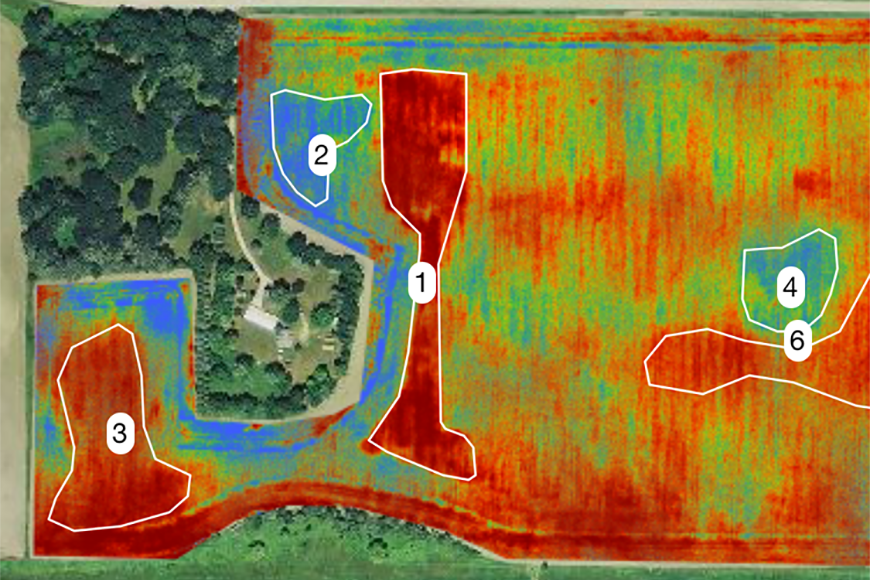
Aker UAV (unmanned aerial vehicle) imagery, combined with a review by a staff of agronomists, creates scouting zones that define areas of concern. This verification allows calculation and prioritization via financial threat of field problems — be it weeds, diseases, insects, or compaction or drainage issues — for quick action. Aker uses current market prices and crop yields to project the potential cost of not taking action.
Three types of imagery
Different field conditions may require different imagery to best indicate areas of concern. AkerScout™ imagery provides a clear, quick snapshot of field health so that prompt action can be taken when necessary.
Farmers involved in the pilot phase of AkerScout™ found the tool easier and more intuitive to use than some other scouting apps. They also liked having the ability to use imagery for directed scouting and to make better management decisions in the same app, making crop management and precision tools simpler and easy to adopt.
To find out more about AkerScout™ and how it can help you improve your crop scouting efforts, contact your local WinField United retailer.
![]()
AkerScout™, just released May 1, is one of those tools. A directed crop scouting mobile and web app from precision ag company Aker, AkerScout™ helps identify and prioritize damage across multiple fields and crops to address areas that need immediate attention.
Features and benefits
AkerScout™ comes with a base set of features that are free; however, various premium features are enabled when high-resolution aerial vegetation imagery is loaded. The AkerScout™ base free app offers:
- A comprehensive database supporting over 70 crops to identify pests, diseases and plant-limiting environmental stresses.
- GPS-enabled crop scouting with identification and capture of disease, pests, weather, plant population, severity of damage, photos and notes.
- Field mapping and comprehensive reporting.
- Compatibility with iOS and Android across phones and tablets.
Aker UAV (unmanned aerial vehicle) imagery, combined with a review by a staff of agronomists, creates scouting zones that define areas of concern. This verification allows calculation and prioritization via financial threat of field problems — be it weeds, diseases, insects, or compaction or drainage issues — for quick action. Aker uses current market prices and crop yields to project the potential cost of not taking action.
Three types of imagery
Different field conditions may require different imagery to best indicate areas of concern. AkerScout™ imagery provides a clear, quick snapshot of field health so that prompt action can be taken when necessary.
- RGB imagery: Documents crop stresses that can be seen with the human eye.
- Normalized difference vegetation index (NDVI) imagery: Defines zones of plant health and can be used for nitrogen prescriptions, fungicide recommendations and to confirm nutrient uptake.
- Thermal imagery: Informs irrigation management decisions, defines soil management zones and documents diseases.
Farmers involved in the pilot phase of AkerScout™ found the tool easier and more intuitive to use than some other scouting apps. They also liked having the ability to use imagery for directed scouting and to make better management decisions in the same app, making crop management and precision tools simpler and easy to adopt.
To find out more about AkerScout™ and how it can help you improve your crop scouting efforts, contact your local WinField United retailer.