Satellite “movies” will reveal insights about crop progress, opportunities to boost yield
.jpg?ext=.jpg)
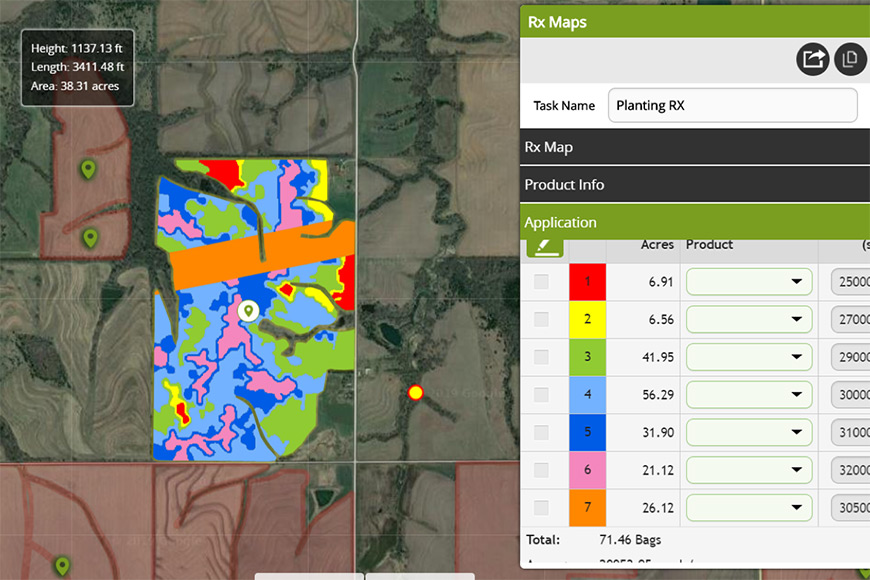
Satellite imagery is the cornerstone of many of the ag technology applications you use throughout the year. It helps you scout with precision, inform tissue sampling programs and map a field’s yield potential, profitability and more. GEOSYS, the Land O’Lakes company providing satellite data service, has forged an agreement with UrtheCast, a premier Earth observation satellite company, to secure the best “eye in the sky” for farmers.
With UrtheCast’s new satellite constellation, UrtheDaily, you could look up in the sky around 10:30 every morning and know a satellite was passing overhead, capturing images of your fields down to a 5-meter resolution. With this daily high-quality in-season imagery, you would be able to gauge crop nutrient needs, plan scouting needs and more.
“It will be like looking at a movie of your fields and developing crops with greater detail and better reliability than anything on the market now,” says Dave Gebhardt, Ph.D., global director of strategic partnerships for GEOSYS. “Working with their agronomy teams, farmers can have great confidence in success when they use the prescriptions generated by leveraging this data.”
It’s easy to see how a daily source of accurate imagery could impact your bottom line. “You can make decisions quickly on purchasing plant nutrients or crop protection products based on ROI,” Gebhardt says. “Using this technology will help farmers make data-based decisions with even more precision than is already possible with current satellite imagery capabilities.”
Ultimately, a daily view from above will be a necessity for every farmer, says Gebhardt. “And UrtheDaily is satellite imagery on steroids.”
This photo represents a simulation of what will be available through the new satellite imagery offerings via UrtheDaily.
Related Articles