Drone On!

The new Small Unmanned Aircraft Rule (Part 107) is in effect as of August 29, 2016. When the Federal Aviation Administration (FAA) finalized the first operational rules for routine commercial use this summer, we boiled down what these new drone regulations mean for the ag industry. If you’re thinking about investing in an unmanned aircraft system (UAS), also knows as drones, make sure to review these rules.
If you’re not sure what to realistically expect from a UAS, you’re not alone. Drones are still in the “curiosity” stage for most farmers. Many seem interested in them, but the industry is still hashing out how farmers can use drones optimally without being cost-prohibitive.
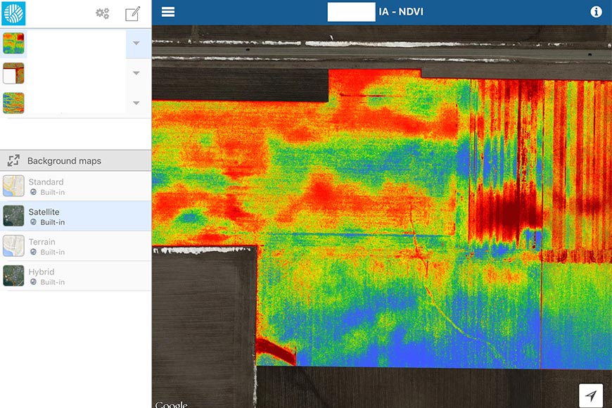
Broadly speaking, drones can currently provide three different types of imagery, depending on the equipment and what the farmer wants to determine.
To learn more about what types of drone technologies may make sense for your operation, listen to The Deal With Yield® episode I cohosted.
If you’re not sure what to realistically expect from a UAS, you’re not alone. Drones are still in the “curiosity” stage for most farmers. Many seem interested in them, but the industry is still hashing out how farmers can use drones optimally without being cost-prohibitive.
Broadly speaking, drones can currently provide three different types of imagery, depending on the equipment and what the farmer wants to determine.
- RBG or true color photos are aerial photos taken with a 35 mm camera, which provide a bird’s-eye view of fields.
- NIR/MultiSpec/HyperSpec photos provide normalized difference vegetation index (NDVI) maps and help visualize which areas are healthy or stressed by measuring biomass.
- Thermal photos, which identify crops that can best tolerate drought or cooler temperatures.
To learn more about what types of drone technologies may make sense for your operation, listen to The Deal With Yield® episode I cohosted.


